The N73 motorway was a planned motorway from Kessenich, via Bree, Hechtel-Eksel, Leopoldsburg, Ham, and Tessenderlo to Aarschot. The section between Kessenich and Leopoldsburg is a 2-lane single carriageway with frontage access, going trough all those city centres except for Peer, where it runs south of the city. Between Kinrooy and Peer the road is a 4-lane dual carriageway.
What about the N73 west of Leopoldsburg? A more or less local road of the same number continues to the next village of Heppen. West from there, there’s no road numbered N73…
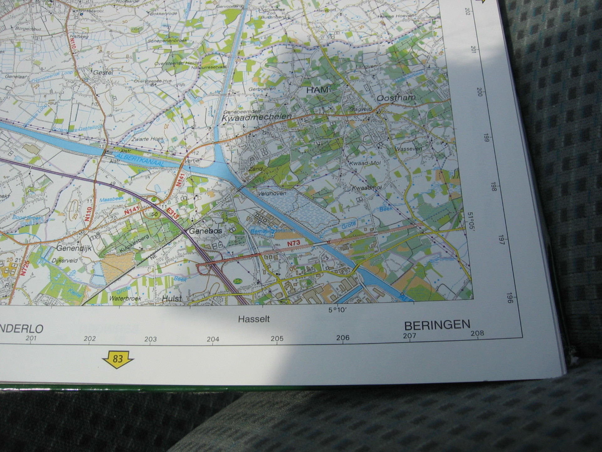
In brilliant red is the in-use section of the N73 between the motorway and the industrial lot. The thinner lines mark the “under construction” sections with four bridges in it. Of those, only the middle two exist.
… Nothing, except for a 1-km, 4-lane, dual carriageway, almost-grade-separated section, which connects the motorway E313 to an industrial park. If you look at a road map, there is no N73 if you look between those sections. If you look at a good topographical map, or aerial images, one sees a straight line going east towards Heppen, almost (but not quite) connecting the two N73 sections, and in doing so, crossing the Albert Canal – one of the wider canals in Belgium.
Gewestweg N73 was gepland als autoweg van Kessenich, via Bree, Hechtel-Eksel, Leopoldsburg, Ham en Tessenderlo naar Aarschot. Het deel tussen Kessenich en Leopoldsburg is een tweebaansweg die door alle stadscentra loopt, behalve in Peer, waar een rondweg ten zuiden van de stad is gemaakt. Tussen Kinrooy en Peer is de weg uitgevoerd als vierbaansweg met gescheiden rijbanen.
En de N73 ten westen van Leopoldsburg? Een min of meer lokale weg met hetzelfde nummer loopt door naar het volgende dorpje, Heppen. Ten westen is er geen weg meer genummerd als N73…
… Behalve een 1 kilometer lang stuk bijna-ongelijkvloerse vierbaansweg met gescheiden rijbanen, die de Autostrade(autosnelweg) E313 met een industrieterrein verbindt. Als je op een wegenkaart ziet, zal je geen N73 tussen deze delen vinden. Maar kijk op een goede topografische kaart of luchtfoto’s, en je ziet een rechte lijn naar het oosten lopen, richting Heppen. Die lijn verbindt bijna (maar niet helemaal) de twee delen van de N73, en kruist daarbij het Albertkanaal, een van de bredere kanalen in België.
-

- The bridge over the Nijverheidsweg The bridge deck itself has asphalt, but no cars will pass over it.
-

- From the bridge over the Nijverheidsweg (with asphalt on both lanes), looking west toward the bridge over the Albert Canal
-

- Looking west from the easternmost point of the N73 earth dam. At my feet, there’s a gap that used to have a forest road trough it, but someone created a half-assed ramp so now that one is disconnected. Behind the heap of sand is the bridge over the Nijverheidsweg, and at the horizon the bridge over the Albert Canal
Ok, we’ve kept hopping east and west. For now, I’m gonna go right to the center, to the small details. And when I say small, I mean a truck could pass under it. Who calls something a full size truck can pass under a small detail? Well, relative to what’s next, it’s a small detail.
Look at the Nijverheidsweg overpass: the leftmost image above. It doesn’t look too special from below, but the image next to it is the view from the top of the overpass. The bridge itself can handle cars, but for the part where a road would normally connect, you need a Landrover or better. Even more to the east, it’s all sand, conquered by nothing but dirt bikes.
Below is a larger view from top of the Nijverheidsweg bridge.
We zijn van oost naar west blijven springen, maar nu, op naar het midden, naar de kleine details. En met klein bedoel ik dat er een vrachtwagen onderdoor past. En waarom noem ik iets waar een vrachtwagen onderdoor past een klein detail? Omdat het, ten opzichte wat volgt, maar een klein detail is.
Kijk naar het viaduct over de Nijverheidsweg (de linker foto hierboven). Van beneden af zie je er niets vreemds aan, maar ernaast zie je het beeld van bovenop. Op de brug zelf passen auto’s, maar daar waar er normaal een weg aan vast zit, heb je nu een Landrover of beter nodig. Nog oostelijker is de dam slechts zand, het domein van niemand, behalve de crossmotoren.
Hieronder nog een groter beeld van boven op het Nijverheidswegviaduct.

View from top of the Nijverheidsweg bridge in Ham. Click to enlarge
A little more to the west lies a not-so-small detail. How not-so-small? Well, a tow boat with barges will fit under it. And sheep will fit on it. Sheep? Yes, in Ham they’ve built a bridge with a 150 metre span, able to hold four lanes of traffic, and it is crossed by … sheep. They graze on grass that grows where you’d expect asphalt, and just look up at the occasional citralogist. The bridge also has fertile soil for blackberries, which is excellent citralogist food.
To be honest, it’s not one bridge but two bridges next to each other, with concrete plates between them. Only one of them has grass, the other has asphalt. Both bridges are equipped with guard rails (in dire need of some fresh paint).
Een stukje naar het westen ligt een niet-zo-klein detail. Hoe niet-zo-klein? Nou, hier past een groot duwvaartkonvooi onder. En er passen schapen op. Schapen? Ja, in Ham hebben ze een brug met een overspanning van meer dan 150 meter gebouwd, waar vier rijstroken op passen, en dagelijks passeren er … schapen. Ze grazen gras daar waar je asfalt zou verwachten, en kijken slechts af en toe op, als hier een citraloog langs komt. De grond is ook vruchtbaar, er groeien bramen, en dat is uitmuntend citrologenvoer.
Eigenlijk is het niet een brug maar twee naast elkaar die hier liggen, met betonplaten er tussen. Slechts één van de bruggen heeft een grasdek, de ander is “gewoon” geasfalteerd. Beide bruggen hebben vangrails en een balustrade, maar die heeft wel een lik verf nodig.
-

- From the east bank of the Albert Canal. The span of this bridge is about 150m, the entire bridge is about 250m long. It’s actually a set of two completely separate bridges, with a thin concrete-with-glass-tiles deck inbetween.
-

- Someone decided to add soil, then grass, to half of the bridge, and make it a meadow for sheep. The sheep weren’t used to people (citrologists) using the other, asphalted, half of the road. Behind the far guard rail you can see the (overgrown) pavement.
-

- The maintnance on this bridge is top notch.
-

- Food growing on the bridge
-

- Looking towards the western bank. The far pylon of the left bridge has a plaque “HAM KM 72.777” (being the name of the nearby hamlet and the kilometre point of this bridge)

The bridge over the Albert Canal; two lanes of asphalt and two lanes of grass. Click to enlarge.
So, what happened here? The N73, as stated in the intro, was planned as a road from Kessenich to Aarschot. The road was built out from older roads of Napoleontic age betwen Kessenich and Leopoldsburg, but west of there the road would follow an entirely new route, which was still open for debate in the early ’80’s. The municipality of Tessenderlo desired a connection to Aarschot, and if that wouldn’t be built immediately, the entire road wouldn’t be built at all. In the meanwhile, the large bridge over the Albert Canal had already been constructed back in 1977. But when the crisis of the ’80’s hit, the N73 was one of the first projects to get defunded. Nothing has ever been heard of it since.
The only part of the “new” N73 that sees actual cars on it is the 1 km-long section between the E313 motorway and the access road (known as Snelwegstraat, Highway Road) to a large industrial lot. Even for this use, it’s terribly oversized and no longer in lines with current ideas on traffic safety. At the highway end, there is a sudden decrease from two lanes to one, and then a sharp turn to the left – so sharp, it has red arrows and a series of flashing orange lights. Beyond those lights, some 30 more metres of asphalt (already reclaimed by nature) is visible. Tessenderlo lies in the distance …
Wat is het achterliggende verhaal? Zoals in de introductie te lezen valt was de N73 gepland als weg van Kessenich naar Aarschot. Tussen Kessenich en Leopoldsburg was de weg uitgebouwd van oude Napoleontische wegen, maar ten westen daarvan was er een compleet nieuw tracé nodig, dat in de vroege jaren ’80 nog onderwerp van debat was. De gemeente Tessenderlo wilde direct een weg naar Aarschot, óf helemaal geen weg. Ondertussen was in 1977 de grote brug over het Albertkanaal al gebouwd. Maar in de crisis van de jaren ’80 werd de N73 een van de eerste projecten die geschrapt werden. Sindsdien is nooit meer iets van het project vernomen.
Het enige deel van de “nieuwe” N73 waar verkeer overheen gaat is het 1 km lange deel tussen de snelweg E313 en de toegangsweg (Snelwegstraat genoemd) tot een groot industrieterrein. Zelfs hiervoor is de N73 enorm overbemeten, en voldoet niet meer aan de huidige ideeën van verkeersveligheid. Aan het snelwegeinde is een scherpe bocht naar links – zo scherp, dat er borden met rode pijlen en een set knipperende gele lampen hangt. Na deze lampen is nog zo’n 30 meter asfalt (deels alweer teruggewonnen door de natuur) te zien. Tessenderlo ligt in de verte …
-

- The short section of N73 that is in use, driving east, towards the overpass over the E313
-

- The Western end of the N73. Go left to go upon the E313 towards Liège, or straight on to go towards Aarschot. Bring a car that can do rugged terrain.
Maps:
Visit date / datum bezoek:
August 18, 2005
Status at last visit / status bij laatste bezoek:
- N73, from the exit 25a of the E313 to the Snelwegstraat (highway street): 4-lane separated road, in use.
- 250m-long Bridge over the Albert Canal (2 lanes asphalted, 2 potential lanes in use as sheap meadow)
- Unused over the Nijverheidsstraat
- Earth dam between those sections
- N73, vanaf afrit 25a van de E313 tot aan de Snelwegstraat (highway street): 4-baans gescheiden weg, in gebruik.
- 250 meter lange brug over het Albertkanaal (2 rijbanen geasfalteerd, niet in gebruik, 2 potentiele rijbanen in gebruik als schaapsweide)
- Ongebruikte brug over de Nijverheidsstraat
- Aarden dijk tussen deze delen.
Current status / huidige status:
Unknown, but probably (looking at Google Maps) exactly the same as in 2005. / Onbekend, maar waarschijnlijk (kijkend naar Google Maps) precies hetzelfde als in 2005.
Future status / toekomstige status:
unknown / onbekend
Source / Bron
Douglas de Coninck: Blijvende Blunders: De grote nutteloze werken